18 Attractions to Explore Near Schilt
Top Activities Near Schilt
Filter By Date
//
Sort By

Attractions & Activities Near You
Checkout attractions and activities near your current locationAll attractions near Schilt
SchwarzstöckliA high mountain which was located in the heart of Glarus. The view from the top of the mountain is truly interesting and the hike to the top of the mountain is quite dangerous. You can explore the natural beauty of the Glarus from there.
MurgseefurggelMurgseefurggel is a pass in Switzerland and has an elevation of 1985 meters. Murgseefurggel is situated east of Alpegligen, northwest of Mittlerer Murgsee. It was one of the picturesque locations in this area and it gives a nice experience of nature.
Kunsthaus GlarusThe Kunsthaus Glarus is a museum and exhibition center in Glarus, in the immediate vicinity of the train station in the Volksgarten. The museum's collection includes paintings and sculptures by Swiss artists from the late 19th and 20th centuries, as well as the collections of Othmar Huber, Gustav Schneeli, and Gustav Egger.
GufelstockThe Gufelstock is a mountain of the Glarus Alps, overlooking Schwanden in the canton of Glarus. The border with the canton of St. Gallen runs on the northern base of the mountain. One of the beautiful area for a picnic and also a good trekking area too. Swimming and fishing are also possible in the lake which is located in the valley.
MürtschenstockThe Mürtschenstock is a 2441 m above sea level. M. high mountain in the canton of Glarus in Switzerland, which is particularly striking from the Lake Zurich area. The mountain range, elongated in a north-south direction, is characterized by steep rock faces on all sides. The most important peaks are called Ruchen, Fulen, and Stock. It was one of the beautiful trekking destinations and also an area to refresh your mind.
Vorder GlärnischThe Vorder Glärnisch is a mountain of the Schwyzer Alps, overlooking the valley of the Linth in the canton of Glarus. It lies north-east of the higher Glärnisch (2,914 m). Unlike its higher neighbor, the Vorder Glärnisch can be ascended via a trail on its north-west side. It was one of the main trekking destinations in this area and also a tourist-friendly area.
LöntschThe Löntsch is a stream in the Swiss canton of Glarus. It drains the Klöntalersee and flows into the Linth near Netstal. The course of the stream through the narrow valley reaches a climax with the deep Löntschtobel, which can be observed from the Löntschtobel bridge. An important source river of the Löntsch is the Chlü, which is the largest source river of the Klöntalersee.
WiggisThe Wiggis is with a height of 2,282 meters and especially with its location close to the capital one of the most important mountains of the Swiss canton of Glarus . The summit pair Wiggis and Rautispitz is perceived by the valley as a coherent massif. Trekking is possible here and also rock climbing too. The natural beauty of this area attracts a lot of tourists and you can spend some beautiful time here,
OberblegiseeOberblegisee is a lake in the Canton of Glarus, Switzerland. It is located at an elevation of 1,422 metres, above the village of Luchsingen and below the peaks of Glärnisch. Its surface area is 0.17 square kilometres. A good picnic point, There is also an opportunity for trekking too.
GlärnischThe Glärnisch is a mountain massif of the Schwyz Alps, overlooking the valley of the Linth in the Swiss canton of Glarus. It consists of several summits, of which the highest, Bächistock, is 2,915 metres above sea level. Until 2013, the highest point was considered to be an unnamed point with a summit cross at 2,914 metres. The other main summits are Vrenelisgärtli and the Ruchen. A good trekking destination and also suitable for other adventure activities.
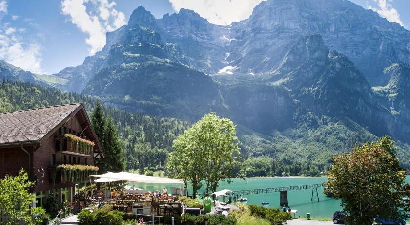
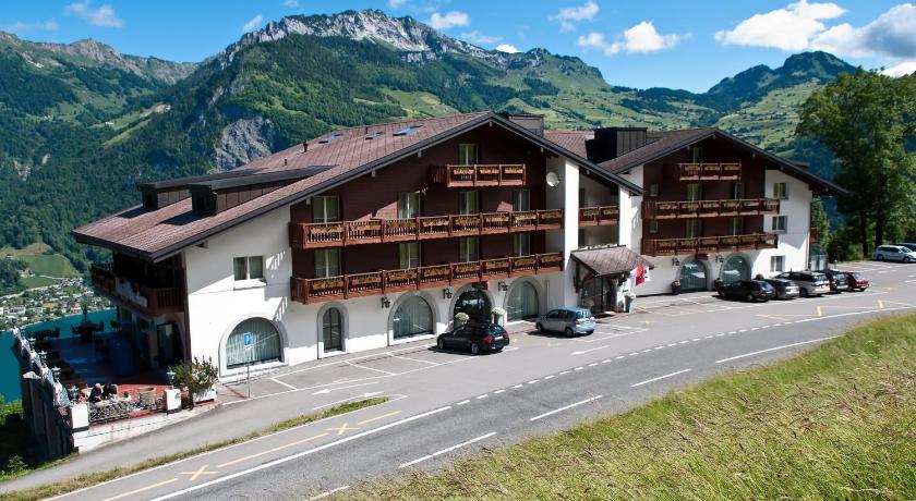
KlöntalerseeThe Klöntalersee is a big alpine lake surrounded by mountains, a lovely place for a picnic, and a leisurely walk. We discovered this by accident and even though it’s quite popular, it still seems like a quiet secret place. It is one of the popular picnic destinations and is suitable for all age groups.
ChöpfenbergThe Chöpfenberg is a mountain of the Schwyzer Alps, located on the border between the Swiss cantons of Schwyz and Glarus. It lies on the range north of the Mutteristock, between the valleys of the Wägitalersee and the Linth. A good picnic destination and also a trekking destination too.
Crap Sogn GionCrap Sogn Gion is a mountain and cable car station located near Flims in the Swiss canton of Graubünden. Regarding the definition used in the Alps by the Swiss Alpine Club it cannot be called a mountain but only a location at the end of a ridge descending from the Vorab in the Glarus Alps. A very small hut of the Ski Club Flims was the first building on Crap Sogn Gion.
Hoch-YbrigThe Hoch-Ybrig is a hiking and winter sports area in the canton of Schwyz in Switzerland. is dominated by the mountain peaks Drusberg, Forsberg, and Twäriberg. This mountain range forms a border ridge against the Muotatal and Glarnerland. There is a cable car available to reach the summit and it offers a panoramic view of the area.
GemsfairenstockThe Gemsfairenstock is a mountain of the Glarus Alps, located on the border between the Swiss cantons of Uri and Glarus. It lies east of the Klausen Pass, on the range east of the Clariden. A trail leads to its summit via the western ridge.
OfenlochThe Ofenloch is a gorge and a grotto in Toggenburg not far from Schwägalp in the Swiss canton of St. Gallen. The Necker rises in this area and flows into the Thur near Lütisburg. The Ofenloch is also known as the Grand Canyon of Eastern Switzerland. The Ofenloch can be reached on a mountain hiking trail from Hemberg, from Schwägalp, or from Ennetbühl.
Klausen PassThe Klausen Pass is an incredibly scenic drive in the Central Swiss Alps connecting Altdorf in the canton of Uri with Linthal in the canton of Glarus. It might not be among the highest alpine passes, but don't be deluded the Klausen can be challenging. It is a bit of a thrill driving the Klausen Pass.
Schwägalp PassThe Schwägalp is one of the most beautiful and most popular mountain pass in the Swiss Confederation. It is located at an altitude of 1298m. The views from here are truly impressive and It connects Nesslau-Neu St. Johann in Toggenburg in St. Gallen and Urnäsch in Appenzell Ausserrhoden.