Obwalden - 43 Attractions You Must Visit
Contents in This Page
About Obwalden
Geographical center of Switzerland.Types of Attractions in Obwalden


Popular Activities And Trips in Obwalden
Filter By Date
//
Sort By
List of Attractions in Obwalden
Ächerli PassÄcherli Pass is a high mountain pass between the cantons of Obwalden and Nidwalden. It connects Kerns in the canton of Obwalden and Dallenwil in the canton of Nidwalden. The pass road has grades of up to 15 percent. From the road, peaks such as Pilatus, Rigi, Buochserhorn, Titlis, and Stanserhorn are visible.
Mountain Passes
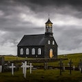
Alte Kirche, AussichtsturmThe old church Lungern is located in the municipality of Lungern in the canton of Obwalden in Switzerland. Only the tower remains of the former church. During the renovation in 1989, a staircase with 78 steps was built in, and the tower has served as an observation tower ever since. The viewing platform provides a view of the Lungerersee and the surrounding mountains Turren, Sädel, Güpfi and Gibel.
Churches
Ballenberg, Swiss Open-Air MuseumBallenberg is an open-air museum in Switzerland that displays traditional buildings and architecture from all over the country. Located near Brienz in the municipality of Hofstetten bei Brienz, Canton of Bern, Ballenberg has over 100 original buildings that have been transported from their original sites. It is a Swiss heritage site of national significance.
Museums
BannalpseeA beautiful reservoir located in the heart of Wolfenschiessen in the Swiss canton of Nidwalden. The lake can be reached by a cable car from Oberrickenbach, which in turn is linked by post bus service to Wolfenschiessen station on the Luzern–Stans–Engelberg railway line. It has a surfaceara of 16 acres and is one of the famous tourist spot in this area.
Man-made Lakes
BonistockBonistock is a mountain with a height of 2168 meters in the municipality of Kerns in the canton of Obwalden in Switzerland . It belongs to the summer and winter sports resort of Melchsee-Frutt . This area can be reached via several hiking trails, in summer with the aerial cableway from Melchsee ands o more.
1 Day Treks
Mountain Peaks
Brünig PassThe Brünig Pass, at an altitude of 1,008 m, connects the Bernese Oberland and central Switzerland, linking Meiringen in the canton of Bern and Lungern in the canton of Obwalden. It is on the watershed between the upper reaches of the Aare, which flows through Lake Brienz and Lake Thun, and the Sarner Aa, which flows into Lake Lucerne.
Mountain Passes
Engelberg AbbeyEngelberg Abbey is a Benedictine monastery in Engelberg, Canton of Obwalden, Switzerland. It was formerly in the Diocese of Constance, but is now in the Diocese of Chur. It is dedicated to Our Lady of the Angels and occupies a commanding position at the head of the Nidwalden Valley.
Religious - Other
Engelberger AaEngelberger Aa is a river in Switzerland. It rises west of Surenenpass in the Canton of Uri, flows through the valley of Engelberg and Nidwalden. At Buochs, it empties into Lake Lucerne and is thus a tributary of the Reuss, which drains that lake.
Lake/ River/ Ponds
Geographical centre of SwitzerlandThe geographical centre of Switzerland has the coordinates 46°48′4″N 8°13′36″ECoordinates: 46°48′4″N 8°13′36″E. It is located at Älggi-Alp in the municipality of Sachseln, Obwalden. The point is the centre of mass determined in 1988 by Swisstopo. As the point is difficult to access, a stone was set 500 m further south-east on Älggi Alp. This symbolizes the centre of Switzerland and is located at 46°47′54″N 8°13′55″E . A plaque on the stone commemorates the winner of the "Swiss of the Year" awar
Outdoors - Other
Glaubenberg PassGlaubenberg Pass is a 19.1 mile point-to-point trail located near Sarnen, Obwald, Switzerland that features a lake and is rated as moderate. The trail is primarily used for road biking, mountain biking, and scenic driving.
Mountain Passes
Glaubenbielen PassGlaubenbielen Pass is a high mountain pass at an elevation of 1.611m above the sea level, located in the Emmental Alps, in Switzerland. The pass is traversed by a road known as Panoramastrasse. The pass itself is located within Obwalden, and connects Giswil in Obwalden and Sörenberg in the Entlebuch region. It divides the basins of the Kleine Emme and the Sarner Aa, both within the Reuss basin.
Mountain Passes
GlogghüsGlogghus is located between the Swiss Canton of Obwalden and the Canton of Bern. It is a mountain of the Urner Alps and a very popular hiking area. The hike is equipped with cables for support against the wet rock slabs. Activities in the summer include walking, touring, biking, fishing, and climbing. In the winter skiing, snowboarding, night skiing, and sledging are available.
1 Day Treks
Mountain Peaks
GrassenA comfortable and relatively easy climbing mountain, Grassen at 2946 meters is the highest and most left summit of the Grassengrat. Located midway between the villages of Berne, Uri, and Obwalden, the picturesque mountain serves as a tri-point. It also offers stunning views of the mountain.
1 Day Treks
Mountain Peaks
Gross SpannortA beautiful mountain located in the heart of the Uri Alps and It is located within the canton of Uri, although its summit lies on the watershed between the Engelberger Aa and the main Reuss valley. The Gross Spannort is almost entirely surrounded by glaciers, the largest being the Glatt Finn. South-west of the Gross Spannort is the Chli Spannort.
Mountain Peaks
Map
Comments
Please Sign In to add your comments
For more information about Obwalden, visit : https://en.wikipedia.org/wiki/Canton_of_Obwalden
This site is protected by reCAPTCHA and the Google Privacy Policy and Terms of Service apply