18 Attractions to Explore Near Pigne d'Arolla
Top Activities Near Pigne d'Arolla
Filter By Date
//
Sort By

Attractions & Activities Near You
Checkout attractions and activities near your current locationAll attractions near Pigne d'Arolla
Grande Dixence damThe world's highest gravity dam which was Situated at the head of the Val des Dix. The dam is 200 meters wide at its base. At the top, it «slims down» to just 15 meters. The Grande Dixence dam is open to the public from mid-June to the end of September. The dam is a visitor attraction and also the starting point for mountain hikes. Guided tours with slide shows and films take place in the interior of the dam. A cable car carries visitors up from the car park and bus terminus to the top of the Di
Lake Place-MoulinThe Lake Place-Moulin is located in the municipality of Bionaz in the Valpelline, side valley of Valle d'Aosta at a height of 1968 m above sea level. It is an artificial lake formed by the waters of the Buthier stream, a stream that cuts through the entire Valpelline. It is one of the largest lakes in the Aosta Valley, together with Lake Beauregard in Valgrisenche, and measures about 4 km in length. The dam, one of the largest barrages in Europe, was built between 1955 and 1965.
Dent d'HérensThe Dent d'Hérens is a mountain of the Pennine Alps, located west of the Matterhorn, along the border between the ' Italy and Switzerland. The watershed between Valtournenche and Valpelline begins on the Italian side from the top of the mountain. On the Swiss side, the mountain dominates the Zmutt Glacier.
Dent BlancheThe Dent Blanche is a mountain in the Pennine Alps, lying in the canton of Valais in Switzerland. It is 4,357 metres -high, it is one of the highest peaks in the Alps. The summit of Dent Blanche is an important geographic place as it is the converging point of three ridges. The three valleys separated by them are the Val d'Hérens, Val d'Anniviers, and Mattertal. The respective villages of Evolène, Zinal, and Zermatt lie approximatively at the same distance as the mountain.
Grand CombinThe Grand Combin is a mountain massif in the western Pennine Alps in the canton of Valais. With its 4,314 metres highest summit, the Combin de Grafeneire, it is one of the highest peaks in the Alps and the second most prominent of the Pennine Alps. The Grand Combin is also a large glaciated massif consisting of several summits, among which three are above 4000 metres, Combin de Valsorey 4,183 m, Combin de la Tsessette 4,134 m. The highest part of the massif is wholly in Switzerland, although the
Mont FortMont Fort is a mountain of the Pennine Alps, located near Verbier in the Swiss canton of Valais. It lies on the range between the valleys of Bagnes and Nendaz, north of the Rosablanche. With a height of 3,328 meters above sea level, Mont Fort is the highest summit north of the Col de Louvie. Mont Fort is surrounded by several glaciers, The summit of Mont Fort is easily accessible by cable car from the heights of Verbier or Nendaz. There is one ski slope leading down from the mountain's peak - wh
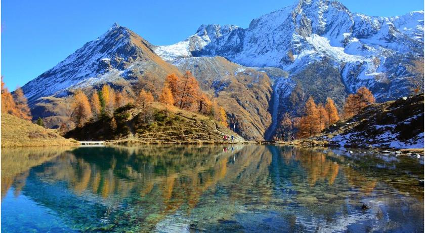
Lac BleuThe Blue Lake or Lake Layet is a lake with origins in the dam which is located just below Breuil-Cervinia in the Aosta Valley. Not far away is the bobsleigh track of Lago Blu, which from 1963 to 1991 hosted numerous international bobsleigh competitions. The lake can be reached by car or on foot from Cervinia in 5 and 20 minutes respectively. The real name is Lago Layet, but it is called Blue because some algae reflect these shades of color at the bottom of the lake.
Matterhorn GlacierThe Matterhorn Glacier is a glacier of the Pennine Alps, also the highest cable car station in Europe, with its new restaurant, The views of the highest mountains in Italy, France, and Switzerland are breathtaking. The ski area on the Theodul Glacier is open 365 days a year. The glacier lies within the basin of the Zmutt Glacier.
MatterhornThe Matterhorn Region or canton of “Valais” is located in Southwestern Switzerland and is home to the most famous mountain in the world. The mountain overlooks the Swiss town of Zermatt, in the canton of Valais. It remained unclimbed after most of the other great Alpine peaks had been attained and became the subject of an international competition for the summit. It is estimated that over 500 alpinists have died on the Matterhorn, making it one of the deadliest peaks in the world.
Val d’HérensVal d'Hérens is an alpine valley in the Valais canton of Switzerland. It was formed by the Hérens glacier, which retreated at the end of the last ice age. It is now the valley of the Borgne river, a tributary of the Rhone. It extends from the Rhône valley to a number of high mountains - Dent Blanche, Dent d'Hérens, Mont Collon, Mont Blanc de Cheilon. It is a popular start point for mountain expeditions.
Plan MaisonPlan Maison is a mountain resort in the municipality of Valtournenche in the Aosta Valley , at an altitude of 2,561 m asl . It is located in the valley Breuil within the ski area Matterhorn Ski Paradise and from there you can start to climb the Matterhorn along the Italian normal route. There are numerous slopes that descend to Breuil-Cervinia: once there were 1 and 2, two black slopes. Today these two tracks are no longer used and are not even marked on the maps. Now, skiers can use slopes 3 an
Ober GabelhornOber Gabelhorn is considered to be one of the nicest Valais mountains. This peak is situated between more famous mountains like Weisshorn, Matterhorn, and Zinal Rothorn. There is no really easy way to the summit. It has very steep flanks on each side. The smooth ice face to the north is very impressive. One of the risky trekking destination and also the climate is very cool.
Lac de MoiryLac de Moiry is a reservoir in the municipality of Grimentz, Switzerland. The lake has a surface area of 1.40 km² and an elevation of 2,249 m. The maximum depth is 120 m. The dam is 148 m high and was completed in 1958. One of the architectural wonders in this area and it attracts a lot of tourists here.
SchwarzseeThe Schwarzsee is a small lake near Zermatt in the canton of Valais, Switzerland. It is located below the Matterhorn next to the mountain ridge and to the cable car station of the same name at an elevation of 2,552 m. Its surface area is 0.5 ha. A chapel dedicated to Mary of the Snows – the chapel Maria zum Schnee – lies on the edge of the lake. It can be reached by cable car from Zermatt. Tou can spend some nice time there and can experience this picturesque location and its climate.
Colle superiore delle Cime BiancheThe upper Colle Delle Cime Bianche is an alpine pass located at 2,980.6 m. slm ., which joins the Valtournenche with the Val d'Ayas in the Valle d'Aosta region. The Colle was of historical importance for the commercial exchanges that took place between the Aosta Valley and the Valais Canton. It is debated whether the Walser in the 13th century arrived in the Lys valley via the Colle del Lys or via the longer but easier road of the Colle del Teodulo, Colle Superiore Delle Cime Bianche, and Colle
ZinalrothornA beautiful mountain which was located in the heart of Switzerland and it was part of the Pennine Alps. It is an ideal location for trekking and also for camping. The view from the top of the mountain is truly astonishing and also It will be a wonderful experience for you.
Theodul PassTheodul Pass, elevation 3,295 meters, is a high mountain pass across the eastern Pennine Alps, connecting Zermatt in the Swiss canton of Valais and Breuil-Cervinia in the Italian region of Aosta Valley. Theodul Pass is the second-lowest pass and the easiest pass between the valleys of Zermatt and Valtournanche. One of the picturesque locations where you can have a ride and also the natural beauty of this area will flourish your mind.
Trockener StegTrockener Steg is a minor prominence in the area between the Matterhorn and the Breithorn, south of Zermatt in the canton of Valais. It lies at a height of 2,939 metres above sea level, near the front of the Upper Theodul Glacier. A cable car station lies on the summit and gives access to the Klein Matterhorn.
Map of attractions near Pigne d'Arolla
Top hotels near Pigne d'Arolla

Know more about Pigne d'Arolla
Pigne d'ArollaPigne d'Arolla is a mountain in the Pennine Alps in Switzerland. The first ascent was made by A. W. Moore and Horace Walker with the guide Jakob Anderegg on 9 July 1865. It is commonly climbed as part of the Haute Route. It is an excellent ski mountain, that is often climbed on the famous Haute Route that leads from Saas-Fee - Zermatt to Chamonix.