Greenlee County - 9 Attractions You Must Visit
Contents in This Page
About Greenlee County
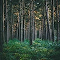
Greenlee County is a county in the southeastern part of the U.S. state of Arizona. This was a land of dinosaurs and active volcano's. Then as time passed indigenous people settled, hunted and fished here for hundreds of years.Types of Attractions in Greenlee County


Popular Activities And Trips in Greenlee County
Filter By Date
//
Sort By
List of Attractions in Greenlee County
Aker LakeAker Lake is located in the White Mountains southwest of Alpine, Arizona, off State Route 191. This lake is located in and administered by the Apache-Sitgreaves National Forests. The lake is stocked with trout and grayling. Tiger salamanders are also found in Ackre Lake.
Lake/ River/ Ponds
Apache-Sitgreaves National ForestThe Apache and Sitgreaves National Forests, administered as one National Forest, encompass over two million acres of magnificent mountain country in east-central Arizona. The major attractions are the Mogollon Rim and the string of man-made lakes. From the Rim's 7600-foot elevation, vista points provide inspiring views of the low country to the south and west. With its high elevation and cool summer breezes it is a popular weekend destination from the hot desert for Phoenix, Arizona, residents.
Outdoors - Other
Forests
Bear Wallow WildernessThe Bear Wallow Wilderness is an 11,080-acre wilderness area in eastern Arizona in the United States.[2] The wilderness, located in the Apache National Forest, is managed by the U.S. Forest Service. The area has been severely affected by the Wallow Fire of June 2011 which originated here. Bear Wallow Creek provides a habitat for the endemic and threatened Apache trout.
Outdoors - Other
Black HillsThe Black Hills of Greenlee County are a 20 mi long mountain range of the extreme northeast Sonoran Desert bordering the south of the White Mountains of eastern Arizona's transition zone. The mountain range is bordered by the Gila River, and the range is a large block that forces the Gila to flow northwest, west, southwest; at the west, the Gila River begins an excursion northwest at the start of the Gila Valley, where Safford and Thatcher lie in the valley.
1 Day Treks
Mountain Peaks
Blue Range Primitive AreaThe Blue Range Primitive Area is the last designated primitive area in the National Forest System. The Blue Range and the presidential recommendation additions together total 199,505 acres and by law are managed the same as congressionally designated wilderness. This is an area of rugged mountains, stark ridges and steep and deep canyons in the Apache-Sitgreaves National Forest against the New Mexico border.
Outdoors - Other
Clifton Townsite Historic DistrictThe Clifton Townsite Historic District, in Clifton, Arizona, is a 37-acre historic district that was listed on the National Register of Historic Places in 1990.It is historically significant as "a largely intact area within Clifton, a copper mining town in eastern Arizona which developed between 1870 and 1930. The district is significant...for its association with the early copper mining and smelting operations in that region and with the town which grew to support those operations.
Outdoors - Other
Eagle CreekEagle Creek is a 58.5-mile-long river located 50 miles northwest of Clifton, Arizona, United States, at the base of the White Mountain Range. It is a tributary of the Gila River.
Lake/ River/ Ponds
Outdoors - Other
Gila Box Riparian National Conservation AreaGila Box Riparian National Conservation Area has many cliffs, canyons, and historical sites to explore. This 23,000-acre BLM property is in eastern Arizona. Within the conservation area, the Gila and San Francisco rivers flow through the area in addition to Bonita and Eagle Creeks. Hiking, rafting, wildlife viewing, and much more await Gila Box visitors.
Outdoors - Other
Guthrie PeakGuthrie Peak is the highest point of the Black Hills, the northern extension of the Peloncillo Mountains in eastern Arizona. It isn’t a major Arizona summit. However, it does enjoy a prominence of over 2,000’, making it a worthwhile destination in its own right. Although it is far from any major Arizona cities. The summit is easily accessible because it starts right off US-191 and has a road to the top. For this reason, Guthrie Peak can be hiked any time of year.
1 Day Treks
Mountain Peaks
Map
Comments
Please Sign In to add your comments
For more information about Greenlee County, visit : https://en.wikipedia.org/wiki/Greenlee_County,_Arizona
This site is protected by reCAPTCHA and the Google Privacy Policy and Terms of Service apply