18 Attractions to Explore Near Monte Mucrone
Top Activities Near Monte Mucrone
Filter By Date
//
Sort By

Attractions & Activities Near You
Checkout attractions and activities near your current locationAll attractions near Monte Mucrone
Monte MarsThe Mont Mars is the highest peak of the Biella Alps. The Valle d'Aosta side has been included in the Mont Mars Nature Reserve since 1993. It is possible to climb the summit on the southern side starting from the Sanctuary of Oropa; the difficulty of the route is estimated as EE; alternatively, you can go up the north side starting from the Lys Valley. One of the nice trekking destination and also a good viewpoint too.
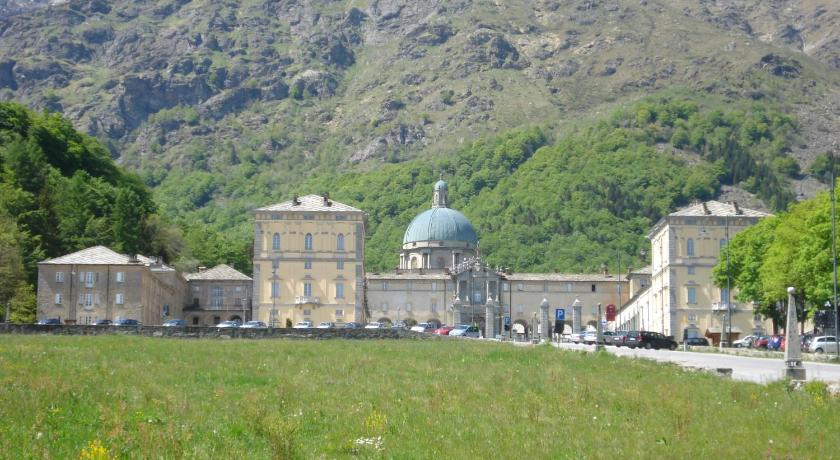
Sanctuary of OropaThe Oropa Sanctuary is the most important and largest Sanctuary dedicated to the Virgin Mary to be found in the Alps. It is located in a unique, natural and unspoilt setting at 1200 mt. a.m.s.l, at only 20 minutes drive from the centre of Biella. The monumental complex is made of three courtyards: the heart of the Sanctuary is the Old Basilica where the Black Madonna is kept.
Fort of BardThe fort of Bard is a fortified complex that was rebuilt in the 19th century by the House of Savoy on the rock overlooking the village of Bard, in the Aosta Valley. After a long period of abandonment, the fort has been totally restored with interventions inspired by conservative recovery: it was opened to visitors in January 2006. It currently hosts exhibitions of ancient, modern, contemporary art and photography.
Oasi ZegnaThe Oasi Zegna is a naturalistic area with free and open access in the province of Biella, Piedmont. Its roots date back to the thirties when the entrepreneur Ermenegildo Zegna , founder of the Zegna Group, after having created the company that bears his name in Trivero (in the Biella Pre-Alps ), dedicated himself to giving new life to his hometown.
Castel SavoiaCastel Savoia(Savoy Castle) is a historic residence located in Gressoney-Saint-Jean, Italy. It is a three-storey eclectic villa characterized by the presence of five towers. The grounds of the castle house the alpine botanical garden "Savoy Castle Alpine Botanical Garden".
Verrès CastleThe castle of Verrès is one of the most famous medieval Aosta Valley manors. Built as a military fortress by Ibleto di Challant in the fourteenth century, it was one of the first examples of a monobloc castle, consisting of a single building unlike the older manors formed by a series of buildings enclosed by a wall. It stands on a rocky promontory that dominates the town of Verrès and the Val d'Ayas road.
Issogne CastleThe Sundial House is one of the most famous castles in the Valle d'Aosta. It is located in the capital of Issogne, on the hydrographic right of the Dora Baltea, and appears as a Renaissance stately home, creating a sort of contrast with the austere castle of Verrès which is almost opposite the opposite side of the river. Famous are its inner courtyard, with the fountain of the pomegranate and the colorful arcades, a rare example of Alpine painting medieval.
Col de JouxThe Col de Joux is an alpine pass located in the Aosta Valley in the municipality of Saint-Vincent. The pass was in the past very popular, and in particular, it was used by the Valsesian emigrants on their way to Savoy and France who, through the Val Vogna , the Valdobbia and Ranzola hills reached the Col de Joux to continue then passing the city of Aosta and climbing to the Piccolo San Bernardo hill.
Lago di ViveroneThe Lake Viverone is the third largest lake in Piedmont in Italy, located in the extreme northeastern part of the Canavese and the extreme southern part of Biella; takes its name from the homonymous municipality to which it belongs. Viverone is a center for day trips and the lakeside communities of Lido, Masseria, Comuna, and Anzasco have recently been connected by a boat service. The lake is also an important archaeological site: villages made up of stilt houses were present here in the Bronze
Val VognaThe Val Vogna is a downstream side of Valsesia, in the territory of the fraction Riva Valdobbia. It extends for 14 km and can be reached from the hamlet of Riva via a small asphalted road which after a few bends reaches the hamlet of Cà di Janzo. From here the road continues slightly uphill to the hamlet of Sant'Antonio.
Testa GrigiaTesta Grigia is a rocky prominence above the Theodul Pass, located on the border between Italy and Switzerland. It overlooks the Plateau Rosa section of the Theodul Glacier on its east side. It is usually climbed from the Gressoney side, where the climb presents no technical difficulties, as the route is assisted by a fixed rope. The summit offers a fine balcony view of Monte Rosa and the Matterhorn.
Lago GabietThe lake Gabiet is a reservoir of Valle d'Aosta. The basin is located in the Lys valley above Gressoney-La-Trinité at an altitude of 2,373 m asl and feeds the Gressoney-La-Trinité hydroelectric plant and allows the generation of 11 MW, with a production of 14.5 GWh / year. The dam that made up the lake, made by a massive gravity dam, was built between 1919 and 1922. The lake can be reached via the gondola that goes from Stafal to just below the lake.
Parco Naturale Mont AvicThe Mont Avic Natural Park is a protected natural area in the Aosta Valley and has an area of over 5,747 hectares. The first regional natural park in the region, after the Gran Paradiso national park, created in 1989 and enlarged in 2003, it extends between the Champdepraz valley and the Champorcher valley, crossed by the Chalamy stream, in a secluded position from the major Aosta Valley tourist routes.
Castello di UsselThe Ussel castle is one of the castles medieval of Valle d'Aosta. It is located on top of a rocky ridge overlooking the village of Châtillon, in a position that guarantees control of the entrance to the Valtournenche and the valley floor of the Dora Baltea. The castle rises on a serpentinite rock, separated from the rest of the mountain by the "Aosta- Ranzola " fault worked over the centuries by the Pleistocene glacier.
Monte ZerbionThe Monte Zerbion, also spelled as Dzerbion , is a mountain of Alps Monte Rosa in the Pennine Alps. It is located in Valle d'Aosta along the watershed between Valtournenche and Val d'Ayas. On its top, there is an imposing statue of the Madonna. From the summit, you can enjoy a broad view of the surrounding peaks and a large part of the Aosta Valley. The summit can also be climbed in winter on skis.
Passo dei SalatiThe step of Salati is a mountain pass that constitutes the natural border between the Valsesia and the valley of Lys, respectively, in Piedmont and Valle d'Aosta. The pass opens between the Corno del Camoscio and the Stolemberg. It is reached by two important and modern cableways, a cableway coming from Gressoney-La-Trinité and a funifor from Alagna, included in the extensive Monterosaski ski area, one of the largest in Italy.
Castle of Baron GambaThe Gamba castle, from the historical point of view, is the castle "child" of the three in the municipality of Châtillon, in Valle d'Aosta: what Passerin d'Entrèves and to Ussel is in fact medieval era. The Gamba castle, dating back to the twentieth century, is located on a hillock in the western part of the town, in the locality of Cret-de-Breil, near the regional hotel school, and is completely surrounded by a park open to the public all year round. It is clearly visible from the A5 motorway.
Colle BettaforcaThe Bätt pass is a pass in the Pennine Alps at an altitude of 2,727 meters in the Aosta Valley, between the Ayas valley and the Lys valley. This pass is commonly called col de Bettaforcaz, Frenchization of the word Bättfòrkò, meaning precisely col du Bätt in the titsch of Gressoney-La-Trinité. But it should be noted that the toponym Col de Bettaforcaz is in fact a repetition.
Map of attractions near Monte Mucrone
Top hotels near Monte Mucrone


Know more about Monte Mucrone
Monte MucroneThe Monte Mucrone is a mountain of Biella Alps high 2,335 m. It is located in the Province of Biella between the Elvo Valley and the Oropa basin and the municipal boundaries of Biella, Sordevolo and an administrative mountain island in the municipality of Pollone converge on the culminating point. Like the rest of the Oropa basin, the eastern slopes of the Mucrone were included in 2005 in the special nature reserve of the Sacro Monte di Oropa.